At FeatureX, we are interested in building deep learning engine that understands the semantics in any given satellite imagery. We are pursuing a general-purpose detection system: that is, a model that can be easily adapted to any ad-hoc prediction task asked by the client. The system should be able to tackle a variety of different tasks, from detecting vehicles, counting trees, predicting crop yields, demographic survey by mapping building footprints, to tasks the system has never seen before.
As a research scientist, I work on designing models that work across a variety of image detection / segmentation scenarios. We have developed a robust framework that achieves state of the art performance for many prediction tasks we currently work on.
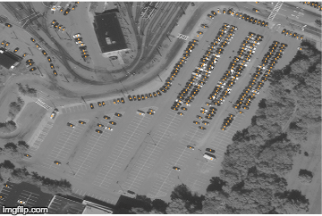
One iconic example is vehicle detection and characterization in satellite images. Vehicle is one of the smallest identifiable objects seen from space. We are able to detect densely packed cars with accurate localization.
In addition to good detection accuracy, I am also concerned with sharp prediction. The reason is to provide very fine-grained information for a satellite image, which effectively expands the possibility of what we can do with satellite image analytics.
We are able to use neural network to produce very fine-grained building footprint prediction, whereas typical fully convolutional network does not provide such detailed prediction.